After five years of community development and consultation, a draft Neighbourhood Plan for Roman Road Bow has been validated by a meeting of the Tower Hamlets Council Cabinet on Wednesday 24 November, and is now out for public consultation until the end of January. If you can please spend some time responding to the consultation and give your views on the development and use of land in the area.
Alex, Chair of Roman Road Bow Neighbourhood Forum continues:
If successful, the Neighbourhood Plan will for the first time give local residents the power to shape the planning decisions, economic development and growth in the Roman Road Bow area, by setting neighbourhood priorities that the Borough Council must take into account when making planning and funding decisions.
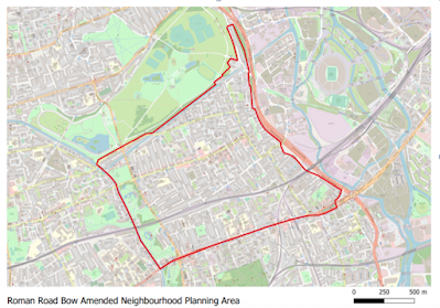
The Neighbourhood Plan area extends from Globe Town to the west, Victoria Park to the north, Mile End to the south and the London Legacy Development Corporation area to the east. It therefore covers key local landmarks including Roman Road Market, parts of Mile End Park and Bow House Business Centre, as well as tens of thousands of local residents.
How was the Neighbourhood Plan developed?
The Neighbourhood Plan has been developed by the Roman Road Bow Neighbourhood Forum following its establishment in 2016. Over the last five years, the Forum has sought to engage as many different groups and individuals as possible to shape the community’s priorities for local planning and community development.
The key themes and policies in the plan are as follows:
- A thriving high street and local economy – encouraging the flexible use of premises
- Green streets that encourage walking and cycling – improving safe walking and cycling routes
- Beautiful public spaces – enhancing public spaces and designating local green spaces
- New life for our local heritage – conserving and enhancing Bow Wharf and designating unprotected local pubs as heritage assets
- High quality affordable housing – supporting affordable, high quality, low-carbon community-led housing
- A resilient and well-networked community infrastructure – supporting new and improved sports and play facilities, and improving existing community facilities
If it is successfully adopted, it will give local residents significant power over the local area up to 2031, including the ability to choose where they want new homes, shops and offices to be built, to have their say on what those new buildings should look like and what infrastructure should be provided, and to grant planning permission for the new buildings they want to see go ahead.
How can I have my say?
The Plan [is out for consultation until the end of January], through the Council’s website.
Details of the neighbourhood plan and supporting documents can be found at https://www.towerhamlets.gov.
Due to restrictions relating to the coronavirus pandemic, hard copies of the neighbourhood plan will not be made available at the Town Hall. Please contact the Plan Making team on the details below if you have difficulty accessing the plan.
Responses to the consultation can be submitted through the consultation web page, or by email to neighbourhoodplanning@
Responses must be received by 5pm on Monday 31 January 2022.
Please speak up! This is a key time to respond, as after this latest consultation, the Forum will be reviewing and updating the plan in the light of feedback received.
What happens next?
After the consultation, the plan then goes to an independent examiner to consider if it meets certain basic conditions and other legal requirements. The examiner can ask for changes to be made, but if the examiner agrees the plan meets legal requirements, it will be recommended to proceed to a local referendum. Everyone in the plan area who is entitled to vote in local elections will be able to vote to approve or reject the plan in the referendum.
If approved, the neighbourhood plan will help shape developments in Bow up to 2031, and it will be a material consideration in the Council considering planning applications. It will form part of the planning framework, sitting under the Local Plan 2031 for Tower Hamlets, which is under the London Plan and the National Planning Policy Framework.
How can I get involved?
1. Fig. 20 title: Proposed School Streets map
ReplyDeleteshows a proposed school street slicing through the middle of Tredegar Square garden. How does this work?
2.What are THC proposals for road traffic changes discussed at consultations. Particularly in relation to Coborn Rd underpass?
That figure isn't well labelled or clear is it! That dotted line going straight through Tredegar Square came up a few years back. I seem to recall it is a green route for walking/cycling rather than a School Street. And they actually meant it is indicative of the general safe walking route from Mile End station to Roman Road and/or Victoria Park.
DeleteThe LBTH proposals for Coborn Road are still being thrashed out. It looks like it may be a part-time CCTV to reduce commuter traffic cutting through Tredegar/Coborn Roads.
You might want to feed this back via the email address in the article neighbourhoodplanning@towerhamlets.gov.uk